The Dixie, as it was called by many, courses the spine of Greenville County, SC, for about 55 miles through rolling hills in the south from Princeton to the metropolis of the city once called Pleasantburg at the Falls of the Reedy on north to the burg of Travelers Rest (a very telling and appropriate moniker) to the beautiful blue mountains by way of the Dark Corner to Tuxedo, NC. Traveling this backbone will take you at least twice as much time as the number of miles might suggest. Google maps suggest 1 hour and 20 minutes without traffic.
The Dixie Highway of 1915-1926 spurred travel and commerce from the northern US to Miami, and Greenville was primed for the Good Road to bring families to view the varied geography this county offers. The upland resorts and inns that sprang up in the 1800s bringing low country gentry to the area in the summers were still in use but beginning to show their age. These new voyagers were most often looking for overnight rests, not lengthy relaxation, so new kinds of lodging sprang up along The Dixie. One such, the Ohio Home Camp, managed by the Whitneys at Woodville south of town, was like so many consisting of individual cabins around a home office.
The mill executives of the upstate looking to promote their businesses and the New South quickly worked to pave The Dixie through Greenville County. They plied their trade of raising funds for mill profits by advertising the upstate as progressive and showed it by putting down concrete, attempting to conceal the issues permeating the Dark Corner, and building cotton mills. The Progressive Era lead to the New South and Good Roads which were key to the growth of the upstate helping to bring the area out of the trials after the War Between the States. Not only did the Progressive New South movement lead to new roads and more manufacturing, education benefited as well. The small school districts all over the county were consolidated in 1926 under the guidance of one superintendent, but it wasn’t until the 1950s that African American schools were upgraded. That’s another story though. WWI didn’t seem to affect the Progressives like the stock market crash of 1929 did, but by that time the paving had been completed.

The Great Depression did slow the vacationers but not commerce and the economic impacts of WWII. The construction of Donaldson Air Base in the 1940s brought soldiers in and out but lots of them stayed. The good roads profited the county’s mills, businesses, and farmers. Then in the 50s Eisenhower’s Interstates opened up the county to travel from Charlotte to Atlanta. And business boomed. The new interstate system has bypassed The Dixie, but remnants of the old DH in the county and state still exist.
So just what is left of The Dixie in Greenville County? That’s an interesting question, and historian, Jim Scott, and I spent a couple of months this past summer delving into that question. From north to south there are seven sections of concrete still unpaved over with macadam or blacktop. We think we have found the complete old DH from North Carolina just below Tuxedo to Princeton at the tip of the county and actually to Augusta. The most of that old concrete is in the area of Moonville.
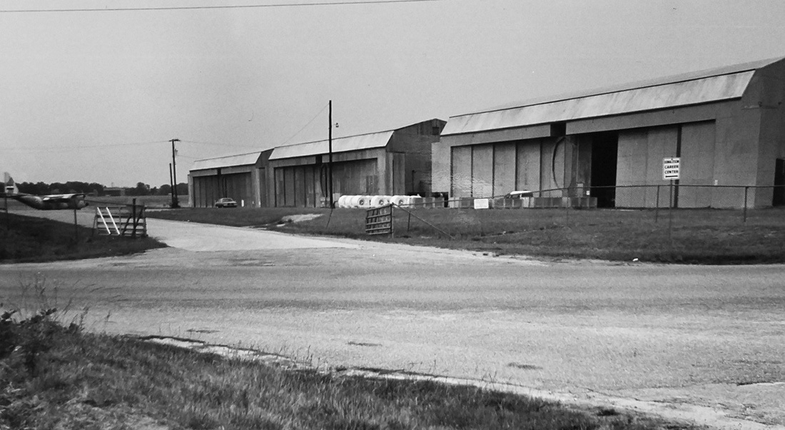
Donaldson being built ca. 1942. Dixie Hwy/Augusta Rd. in foreground. (Archival shared by Bob Dicey) 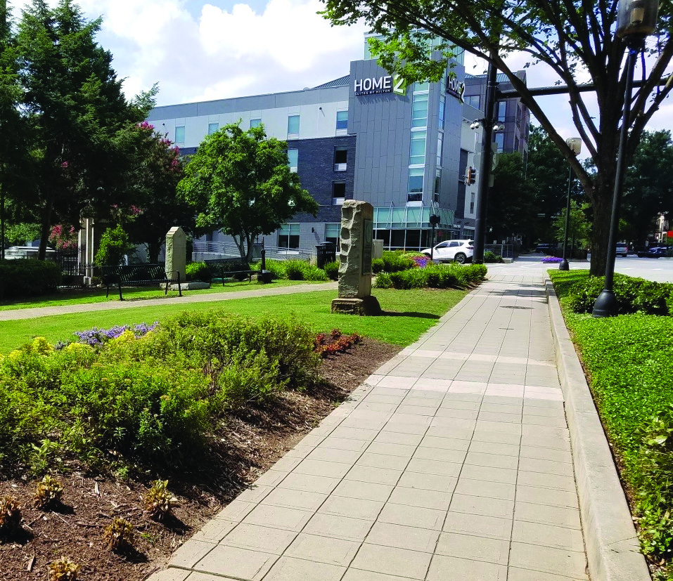
Dixie Highway marker in a small park on Main Street in downtown Greenville. (Anne Peden)

But if you want to retrace the old road, I’d start at the NC line above the watershed on the Old US 25 Hwy, travel down the windy road to the lake of the watershed. Don’t get out of your car here, but if you slow down, you will see a gated road to the left creeping into the woods. Study it carefully along with Google Maps on satellite, and you will see where the concrete leads into the lake to the watery, ghost town of Merrittsville, and then it comes out of the lake to the south. That’s two sections I’m sorry we can’t actually drive on.
Next there are two more sections north of Travelers Rest. One is now called Frontage Road. It’s just south of Hwy. 11. The next piece is Moki Road which goes off to the left of the current US 25 North. Moki Road led past an aged farm house where there was once an interesting area for children with pony rides and a Ferris wheel. The house is still there without the happy sounds of the children.
Next, the DH came down Old Buncombe Road if you want to follow it to downtown and onto Main Street, Greenville, where the United Daughters of the Confederacy placed a granite marker in honor of the road. It now stands with other monuments in front of Springwood Cemetery at Main and Elford Streets. Be sure to park and visit a while.
Now, follow Google Maps to Augusta Road and Old Augusta Road then Donaldson Road onto the Base and around Perimeter Road to Augusta Arbor Way to get to my favorite location, Moonville. There is a gated fence to the left where you turn onto Augusta Arbor. That’s more old concrete running into the airbase. A friend and Donaldson historian, Bob Dicey, showed me how The Dixie went from this spot across the grassy area and knoll to meet Donaldson Road (which was Augusta Road before the base was built in 1942). Enjoy the concrete here and the view of the plane hangers, but turn south on Augusta Arbor straight toward Moonville. Augusta Arbor, as you will see, has been blacktopped in the past few years covering precious concrete, but as you stop at Antioch Church Road and cross over it, there is more unpaved over concrete almost all the way to I-185. The last concrete in Moonville is across the interstate. Turn immediately between QT and McDonalds then right beside Mickey Ds, and the concrete separates the restaurants there from businesses on the left. This is another long stretch of DH that runs into the middle of Moonville at the light. I’m so old I remember the old store building no longer there, but the car lot across from it was a gas station in the 50’s, and my brother-in-law worked there as a young man. He remembers the northerners stopping for gas on the way to Florida!
What a long trip that had to have been. Seems it would have taken nearly a week just coming down. Maybe they were only going to Savannah. I remember reading about folks in the late 1800s driving to the west coast on dirt roads. I cannot imagine! But to drive the Greenville County segment of the DH today would give one a wonderful day trip to many sights I bet you haven’t enjoyed before. Also, don’t miss the historic Goodwin, Spring Park, and McCullough Inns along the way. And if you continue on down the ridge to Princeton following sections of Old Augusta Road which have been blacktopped, you can enjoy 100 homes over 100 years old along the way and very pastoral farm lands surrounding the historic Ware Place, Lickville Presbyterian Church, and Cedarhurst (the McCullough House).
Take time to enjoy Greenville County along The Dixie! The historic Center of Commerce and Travel of the upstate!
Your Road Tripper Friend, Moonville Mae
Search Dixie Highway on Facebook for some interesting reading and to see that folks from the north still visit us as they find The Dixie in SC.♦